Lukesdad14
Site Supporter
I went with these 36.00 on Amazon I like them they function well and look goodThat is a great looking seat, glad you like it. Which hand guards did you go with? :{)

Follow along with the video below to see how to install our site as a web app on your home screen.

Note: This feature currently requires accessing the site using the built-in Safari browser.

I went with these 36.00 on Amazon I like them they function well and look goodThat is a great looking seat, glad you like it. Which hand guards did you go with? :{)
I went with these 36.00 on Amazon I like them they function well and look good
sorry brotherGreat, could you post the link. i just tried looking for those and absolutely nothing came up in my amazon search by name... Thanks! :{)

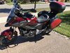
Thought that I would add a pic of the colour added to my ride. I had a local Auto Trim company do a wrap on the bags and the Shad trunk. Total cost was $100CAD.

Not sure, but we think that the person or animal has been employed at Honda doing the same job since at least as far back as 2012.Who is putting these things on so tight?!?View attachment 43282
Who is putting these things on so tight?!?View attachment 43282
I purchased the rear hugger, (fender,) from Impreda online. They are based in Turkey. It took about 6 weeks to get here but got it yesterday and installed it quickly and easily. Looks good to me and more importantly will do the job it is designed for!
View attachment 43277View attachment 43278
Nice hugger, smokey! That looks like the same shape as mine, but mine is made of fiberglass, and I had to paint it to get it to be textured black instead of gloss. Is your hugger just made of plastic and is that the finish it came with? Do you have a link to the seller?
 inpreda.com


CapeMan that looks like a wicked adventure. Thanks for including the photosIt’s an excellent time of year for riding here in the central highlands of Arizona – cool mornings and warmish afternoons and still a goodly amount of daylight too. So ... 2 days, 2 rides.
Day 1 was a day-long ride up onto the Colorado Plateau and into the nation’s (& therefore the world’s) largest Ponderosa forest, and then along the plateau’s southern edge. And, BTW, when I say “edge”, I’m talking a major cliff here, an escarpment that drops from what’s called the Mogollon Rim at roughly 7600 ft elevation to around 5400 ft at the valley floor below. The views from the Rim are outstanding if it’s clear. Unfortunately, smoke from the tragic wildfires in California are making things really hazy here so between that and dead camera batteries, here’s a picture from a previous ride.
View attachment 43297
I rode east on the Rim Road (Fr 300), a well-maintained gravel road that runs about 30 miles right along the edge of the Mogollon Rim. It eventually intersects a highway that runs to the west and down the face of the rim to the bottom of the escarpment. Once down at the bottom of the escarpment, I picked up the Control Road, another well-maintained gravel road that runs 20 odd miles west along the bottom of the Mogollon Rim to intersect another highway that allowed me to close the loop and head on home. Here’s what the Rim looks like from below – a crappy cell phone shot (sorry, dead camera battery, remember?) – I was riding along the top of that cliff edge in the background just an hour or so before this shot.
View attachment 43298
Day 1 summary: 240 miles ridden (60+ on gravel); elevation range: 3100 ft to 7600 ft.; temperature range: 66*F to 94*F, clear skies. This is a ride I try to do at least once a year.
Day 2: Over the Mingus Mountains and thru the old mining towns of Jerome and Clarkdale to the Verde River valley and Tuzigoot Nat’l Monument (which is a 600-900 year-old 100+ room pueblo ruin originally built by the Sinagua people)
Here’s a shot looking back at the Mingus Mtns from near Tuzigoot – you can see Jerome to the left and about half-way up the mountain, right below the “J”. If you look to the right along the mountain ridge, you can see a “notch” just above the top edge of the NC’s windshield – that’s where I’m headed next.
View attachment 43299
So back up to Jerome and then north through the Mingus Mtns on Perkinsville Rd, another well-maintained gravel road. A significant portion of the Perkinsville Rd is on an old railroad roadbed that was used to haul ore from the mines around Jerome. Here’s what the Verde Valley looks like looking back from that “notch” in the pix above; Jerome is just above the NC’s right mirror.
View attachment 43300
Riding on to the north, the views open up again after a bit … here you can see the red rocks west of Sedona in the middle distance and, in the far distance, the San Francisco Peaks near Flagstaff (about 50 miles away).
View attachment 43301
After about 40 miles of riding, Perkinsville Road dumps me back onto pavement at the town of Chino Valley and it’s slab back to the house and close out the loop.
Day 2 summary: 108 miles ridden (40 gravel); elevation range: 3400 ft to 6300 ft.; temperature range: 67*F to 84*F, partly cloudy to mostly clear skies.